Holwell
Ex Somerset parish of Holwell county boundary with Dorset parishes; Folke, Caundle Marsh, Bishop's Caundle, Stourton Caundle, Lydlinch, Pulham and Wootton GlanvilleWednesday 3 August 2016, - 10.00am
The plan is thus:
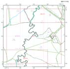
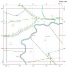
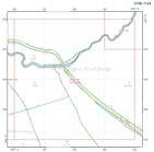
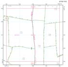
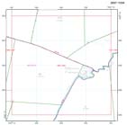
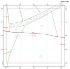
Much looking forward to our second field visit to Holwell on Wednesday 3 August – being a further exploration (the first made in April last year) not of Dorset’s ‘outer border,’ but of a length which formerly enclosed a Somerset ‘enclave.’ Last year we explored the eastern length of the boundary and this time we turn our attention to that south/western.
Until October 1844 the parish/manor of Holwell was enclosed by Dorset, ‘surrounded by that county on every side being more than three miles distant from the nearest part of [Somerset] . . . here stood the principal lodge of the Forest of Blackmore.’ A now lost length of Dorset’s boundary which once defined a village which presents both a ‘borough’ name and a very distinctive settlement plan on the edge of what was formerly managed as a large tract of Common; land foris ‘outside.’ Holwell once formed an important part of the royal manor of Milborne Port – in Somerset.

And once again I’m attaching Holwell as shown on the OS/Cassini map of 1811; the former county boundary is picked out in green, in yellow is Holwell ‘borough,’ with sites along the eastern border we visited last year to which I have added my glo-pen to ‘Round Chimneys’ along the south-western border. Which is where we will meet up.