• The Dorset County Boundary Survey website
Durotriges

Corscombe

A Dorset parish.

Wednesday 7 June 2017, - 10.00 for 10.30am

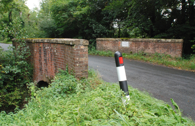
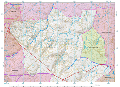
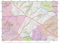
We shall be meeting up in the large car park at Winyards Gap Inn, ST491106, Post Code DT8 3HX, which will (as John Newbould notes who will also kindly lead us) give access to NT land – and a spectacular, panoramic view across the South/NorthPerrott, Halstock/Hardington Dorset/Somerset border.

We will thus be assembling at the Miclan Corf  ‘Great Cut’ or ‘Gap’ recorded in the charter of 1014 ‘whereby King Aethelred grants 13 hides [of land] at Corigescumb to the Sherborne Church.’  A second Corscombe charter in the name of King Cnut ‘at the reputed date of 1035’ granted 16 hides at Corigescumb to the Sherborne Church.  And here the Miclan Corf reference reads Corfget the ‘Gate at the Cut [in the ridge].’   Walking north along the western boundary of Corscombe (a very large parish) will take us to the Miclan Cruc ‘ ‘Great hill’ or ‘barrow’  today’s  ‘Crook Hill’ – cruc  a minor place name inherited from Welsh/Britonnic (Grundy, Dorset Procs, 35, 1935).  And the Corscombe boundary is here joined by the northward running course of the western boundary of Halstock recorded in the charter of AD 841 [Perrott we walked in February 2008 and Halstock in April 2013, June and October 2014]. 

Landshire Lane
Benville Bridge. The turnpike crosses the tributary of the River Hooke (Frome) that defines the boundary here between Corscombe and East Chelborough.
J Childs, 2014
Corsecombe Parish, north
Dorset Boundaries
The northern part of Corsecombe parish with a base over a raster map and basic terrain hillshade. An overlay of turnpike roads

This year 2017, sees the 1000th anniversary of the crowning of Danish King Cnut in 1017. And a pleasure to say that we will be joined by Dr Ken Lawson ‘an acknowledged expert on the late Anglo-Saxon period’ and author of Cnut, England’s Viking King 1016-35; 1993/2011) who recently forwarded me as an attachment his re-translation of Ethelred’s 1014 Corscombe charter of 1014 suggesting it may have been ‘tampered with.’ He notes this will be the first time he has ever walked an A-S charter boundary ‘for real’ ‘on the ground.’ (And not least – one in the name of King Cnut).

Winyards Gap Inn presents itself as an appropriate place for our ‘sit down’ post field-meeting session – noting that it closes at 3pm. Further to this, we have been invited by John Peake of Corscombe Court (a moated site recorded by the OS as ‘Court Farm and remains of Grange’) to visit the 15c barn; Grid Ref St527055, DT2 0NS, sited at the bottom of the hill opposite the Fox Inn. This would be an atmospheric but not overly-comfortable place for our post field-meeting session and suggest that we perhaps visit this (as it were) on the way home. Certainly a site of very considerable interest . . . ‘focus’ of this early ecclesiastical estate where (we may posit), those 11c land surveyors were commissioned to conduct an estate boundary perambulation. The weather may play a part here – and we can talk about this on the day as how to best organise this.

Extract maps (400m x 400m) from OS County Series 1st Edition 1:2500 mapping circa 1886 with digitised feature and boundary overlay. Sheet reference based on full easting-northing 100m grid reference to the lower left internal corner
Sheet Description Boundary Dorset Parish Other Parish link KB size date
INDEX Corsecombe - Winyards Gap  Cheddington, Corsecombe  PDF
Yes, I agree with the licence
agreement. Right Click and
'Save Target As ...'
245 1886
3491-1057 White Hill Plantation 4ft RH, BBCheddington, Corsecombe  PDF
Yes, I agree with the licence
agreement. Right Click and
'Save Target As ...'
301 1886
3490-1061 Winyard’s Gap Inn, North Hill Plantation BB, 4ft RH, FW, 4ft TkB, 4ft RH, 4ft TkH, 4ft RHCheddington, Corsecombe  PDF
Yes, I agree with the licence
agreement. Right Click and
'Save Target As ...'
274 1886
3492-1065 Flaxley Coppice 4ft RHCheddington, Corsecombe, South Perrott  PDF
Yes, I agree with the licence
agreement. Right Click and
'Save Target As ...'
335 1886
3496-1065 Crook Hill 4ft RH, BB

Cheddington, Corsecombe, South Perrott, Halstock

  PDF
Yes, I agree with the licence
agreement. Right Click and
'Save Target As ...'
343 1886
3500-1065 Lane 4ft RHCorsecombe, Halstock  PDF
Yes, I agree with the licence
agreement. Right Click and
'Save Target As ...'
218 1886
             
Parish 1886 - 1:25,000
Sheet Description Dorset Parish Other Parish link KB size date
- Corsecombe, north Corsecombe  PDF
Yes, I agree with the licence
agreement. Right Click and
'Save Target As ...'
291 1840
- Corsecombe, South Corsecombe  PDF
Yes, I agree with the licence
agreement. Right Click and
'Save Target As ...'
291 1840
- Halstock, west Halstock  PDF
Yes, I agree with the licence
agreement. Right Click and
'Save Target As ...'
291 1840
- Halstock, east Halstock  PDF
Yes, I agree with the licence
agreement. Right Click and
'Save Target As ...'
291 1840
Supplementary Information
Sheet Description Dorset Parish Other Parish link KB size date
- Winyard's Gap. Environment Agency Lidar data with 1m contour overlay Cheddington / Corscombe - PDF
Yes, I agree with the licence
agreement. Right Click and
'Save Target As ...'
641 2013
- K Lawson Corscombe Charter boundaries
Boundary clauses
Corscombe - PDF
Yes, I agree with the licence
agreement. Right Click and
'Save Target As ...'
75 2013
- K Lawson Corscombe Charter boundaries
Full translation of the two charters with the Old English boundary clauses and Grundy's translations.
Corscombe  - PDF
Yes, I agree with the licence
agreement. Right Click and
'Save Target As ...'
108 2013
- Domesday Book - Corscombe
http://opendomesday.org - Prof JJN Palmer, Univ of Hull
Corscombe - PDF
Yes, I agree with the licence
agreement. Right Click and
'Save Target As ...'
463 2013
- Domesday Book - Corscombe (Catsley)
http://opendomesday.org - Prof JJN Palmer, Univ of Hull
Corscombe - PDF
Yes, I agree with the licence
agreement. Right Click and
'Save Target As ...'
384 2013
- Domesday Book - Corscombe (Toller Whelme)
http://opendomesday.org - Prof JJN Palmer, Univ of Hull
Corscombe - PDF
Yes, I agree with the licence
agreement. Right Click and
'Save Target As ...'
373 2013
FOX INN
Stalbridge Park wall
Fox Inn, Corscombe
J Childs, 2012

Fox Inn, Corscombe

The Fox Inn is to the east of Corscombe village, north of St Mary's Church. Corscombe Court is along the road to the left.

Ordnance Survey - 2in drawings
Sherborne map 2in drawing

Ordnance Survey - 2in drawing

Copies in the British Library. Corscombe is split between three drawings. A red pecked line describes the border between the counties of Dorset and Somerset.

Winyards Gap Inn
Stalbridge Arms

Winyards Gap Inn

www.tripadvisor.co.uk

The Winyards Gap Inn on the A356 for our initial meet and possibly for our sit-down 'wash-up' afterwards.

Winy