Kingsettle Wood
MotcombeField visit with Kingsettle Woodland Trust
Wednesday 3 April, - 10.00 am
Location: Meet at Wincombe Business Park , Shaftesbury SP7 9Q [ST 869242]
Onward to Kingsettle Wood for 10.30 am
We shall be parking (as some of us will remember) in the Wincombe Business Park [Grid Ref ST 869 242] sited along the east, right-hand side of the A350 running north from the roundabout at the top of the hill on the NW side of Shaftesbury. About a mile along the road there is a large notice reading ‘Wincombe Business Park Entrance’ . Pull in, drive a few yards on to the left and sited on the right hand side is a car park with a cafe in the corner. From here we will walk a few hundred yards up the A350 - then cross over this (very busy) road to the ‘Management’ entrance to Kingsettle Wood and meet up with David Humphries at 10.30.
Now all but half way through March have pleasure in forwarding the meeting-up details for our first field meeting of 2019 to Kingsettle Wood just north of Shaftesbury along our Dorset/Wiltshire border. And which we first walked in April 2015. Our second visit is prompted by a message received from Claire Pinder at County Hall last September further to the interest expressed by the Kingsettle Woodland Trust organiser and volunteers who contacted her last September on hearing about the DCB Research project. They are keen to learn about our recording methodology and our discoveries; and - as RW observes - there remains considerable potential here for further discoveries here before the summer undergrowth 'gets going.' Sarah Stebbing, Woodlands Trust Site Manager for Wiltshire and North East Dorset, has kindly arranged for David Humphries the Warden of Kingsettle Wood to meet up with us at the 'Management entrance' sited on the west side of the A350 about a mile north of Shaftesbury.

HRF Motcombe
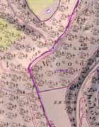
Links for the OS 1901 map of Kingsettle Wood and the HRF kindly completed by Robin Walls following our 2015 visit are listed in the table below. He noted 'that the original county boundary follows a sandstone ridge along the highest part of the wood, reaching a height of 239m (784ft). Whether the ridge is entirely natural or whether it was once enhanced in some way is not entirely clear - at one point there are some large stones, one of them I noted as perhaps 30" by 50". The wood itself belongs to the Woodland Trust . . . The new Wessex Water Corfe Mullen to Salisbury Transfer Main, which crosses the Dorset/Wiltshire boundary at least four times in this area, also impedes us at one point. The old boundary is still today the boundary of a European Constituency! The modern county boundary is along the west side of the A350 road which it would be foolhardy to try and walk along. Again inside the Wincombe Business Park the European Constituency boundary follows the original boundary, in spite of the fact that it now goes through brick walls and cuts buildings in half - an interesting item for the Hercological Record Form.'

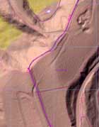
LiDAR DTM
LiDAR is an acronym for Light Detection And Ranging.
The link below relates to the Environment Agency LiDAR 1 metre post-processed Digital Terrain Map (DTM) where the vegetation and man made artifacts have been removed.